Frequently Asked Questions - Parking and Transportation
Will you follow Complete Streets design principles?
YES – a core goal of our proposal favors walking and exercise over life in a car. Complete Streets principles include pedestrian safety, pedestrian and bicycle infrastructure, connections to the broader transportation network, integration with public transportation, transportation demand management strategies, and reducing car dependency.
You may notice that we have created hubs for changing modes of travel, and we have tried to make bike paths as pleasant as possible (not necessarily along a big road). We have tried to create neighborhoods where car traffic is peripheral.
PLEASE CHECK OUT HANIF’S CASE STUDY ABOUT ITHACA NY AND THEIR TRANSPORTATION DEMAND MANAGEMENT.
Have you considered underground parking or on-grade parking with buildings above?
It does not show up in the plan, but in Concept 1 the northernmost row of houses have garages below the houses. You need a 6 to 8 foot grade change for that to work well. Basement costs go way up.
Ground floor parking on level sites eliminates a lot of street-level “life” and a feeling of community, plus it is expensive. In multi-family buildings it generates a need for elevators, which typically must be gurney-sized elevators.
Do you have enough parking, and is it close enough to homes? What is your ratio?
Some of this has been answered before, lower on this page.
We have been looking at ways to reduce distance to homes and also to increase the number of parking spaces.
Regarding parking for city-wide recreation use, if we eliminate some of the City and Turtle Island’s 146 existing parking spaces, we feel an obligation to replace those spaces, hopefully in an optimal location. Additional parking for City functions – including a possible new rec center – is, however, up to the City and should be conceived as part of their own build out.
Could you add another 340 parking spaces, and still maintain the walkable, multi modal nature of most of the neighborhood. Maybe more parking near the fields, an upper lot at the top of what was the sledding hill in 1B, and a lot or two on the E side.
Our original site concept had 239 spaces for residents plus the City’s existing 146 spaces. We can pretty easily add another 60 spaces so that each home has a parking space, but adding much more than that will be up to the City. One strategy we have looked at is on-street parking for the roads accessing rec areas. This also could serve overflow residential parking. If the City wants more parking lots adjacent to fields, that space will have to come out of the fields and at the City’s cost.
Are you flexible on the layout?
We certainly are flexible; all drawings that have been shared are like hypotheses. We look forward to developing a final design with significant public and future resident input.
Evaluate the proposals through the lens of November through April — snow removal, plowing, garages, covered walkways, and practical parking. Renderings only show summer scenes.
We have been thinking about plowing and snow storage, hopefully not removal, and it’s clearly a challenge in a dense settlement. The possibility of heating the pedestrian lanes is exciting… it would not melt snow but would reduce ice.
But icing is clearly a concern that must be addressed.
There are several co-housing projects in Vermont and one we have spoken with in Massachusetts where people do move goods by cart. They seem pretty happy; there is more on this below.

Could there be carports to protect cars from snow?
YES. We described but did not draw canopies over parking areas in our renderings. Solar canopies would be a key part of our parking areas. There will also be EV chargers.
How will the modular design and site grading prevent building runoff from icing over the proposed "multi-modal hubs" and pedestrian paths during a typical VT winter? How will the proposed multi-modal hubs and internal transit be maintained during the winter months to ensure they remain safer and more accessible?
This certainly is critical, especially in a dense neighborhood. Runoff and snow storage will be carefully designed. Lanes and paths can be pitched to drain. We plan a large number of canopies and shelters to keep snow and rain off of stored equipment and vehicles. In Germany, sand is used rather than salt, and in the spring it is swept up for reuse the next winter. This is just one example… we will work with Public Works and prospective buyers to make sure there is a good design and maintenance plan before construction starts.
The property has only one way in and out. Several respondents flag this as a serious safety concern, especially during floods or emergencies.
We agree this is a very serious concern. We have spoken with neighbors to the north about a wide bike path that can double as an emergency vehicle route. We have also spoken with neighbors to the east and west.
How comfortable and convenient can you make the pedestrian access to Barre Street? Getting more foot traffic into that part of town, to support and grow that commercial district could really multiply the benefits of this development.
This is a high priority for us, and we have budgeted for the construction of a multi-modal path down the hill to the Cross VT Trail. We would like to build a serpentine path designed to national standards, plus a more direct (straight) pedestrian path with steps.
Will there be a bike path up to the development from Rt. 2?
YES, the City shows one on the new access road.
How will you minimize traffic near Turtle Island daycare?
Our Concept 1 leaves the area around Turtle Island as it is, letting the City lead on this topic. We have tried other layouts that build around Turtle Island. If this happens, we suggest that drop off/pick up be south of the building (where it now is) with substantial separation from the access road. The daycare might have adjacent play space to the east. We would work directly with Turtle Island to create a design that works well for them.
Can emergency vehicles (fire, police) access all parts of the village quickly?
YES. Every building has at least one side accessible to a 20 ft wide lane. This is the minimum required by the Division of fire safety for two emergency vehicles to pass.
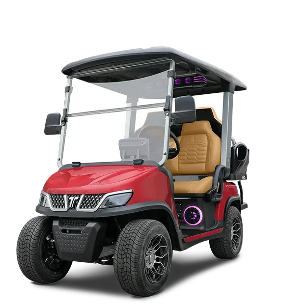
Can golf carts operate on snowy/icy roads?
We need to do more research on this, but the beginning answer is YES, according to a golf cart company called Tara. Here are the modifications they recommend:
1. Off-Road or Winter Tires
2. Cab Enclosures
3. Snowplow Attachment (very cool!)
4. Battery Heater
5. Avoid Steep Slopes
Will people have to walk a long distance from their car to their house?
Our concept design is a starting point. If this is a concern for prospective buyers, we can adjust the design.
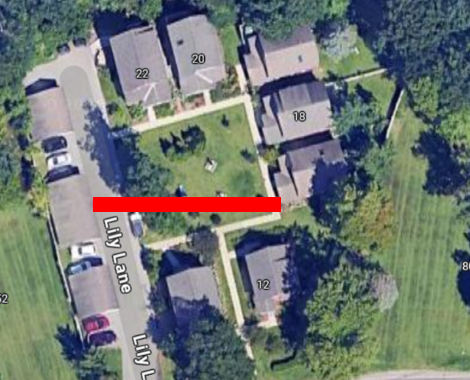
Here is a map of the current distances:
As just one comparison, for distances to walk: Lily Lane in South Burlington VT:
the red bar is 100 ft long.
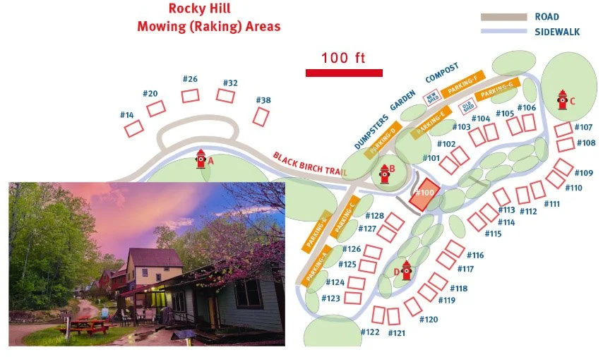
What might transport carts look like?
This great photo was sent by a resident of Rocky Hill Co-Housing in Florence, MA. Residents made these carts themselves, and they have lasted a long time. At Rocky Hill, some people walk more than 400 ft (2-3 minutes) from cars to their homes. Carts get stored near parking and homes.
What are some other examples of walkable communities served by multi-modal transportation?
We did a quick search of New Hampshire, Maine, upstate New York, and Michigan.
How many parking spaces will you have?
Most of the project is one space per dwelling. We currently show 114 spaces for the village, which has 159 units (1 space per 1.4 units). All of the existing City spaces (approximately 146) remain. That brings the total number of spaces to 385 for Concepts 1 and 2, and a total 407 for Concept 3.
It is very easy to add on-street parking for visitors and recreation users.
How do car shares and bike shares work?
Car and bike clubs are expected to be independent from any homeowners’ association and could serve the cottage clusters and big “Park Edge” buildings as well as the village. These clubs are often run as neighborhood- or peer-based operations with unique, agreed-upon procedures. These organizations tend to be place-specific, even if they are regional. For instance, CarShare Vermont operates on a model of dedicated ‘pods’ – dedicated parking space clusters with chargers – for each vehicle. Trips are charged for the period of use until returned to that same pod. Redistribution is not an issue in this model.
Often fleet vehicles are leased, and maintenance is organized by members. The club could have an agreement with a renting/leasing company, such as Enterprise on the Barre-Montpelier Road, for peak travel periods and long distance trips. CarShare Vermont has built-in incentives for “pod nannies,” members who receive a discounted subscription for services provided at their assigned pod.
We expect that bikeshare clubs or providers will be similar to the car-share model, with maintenance done in the community workshop by members, or in partnership with local bicycle businesses.
For bike clubs, their business model can either be “AtoB” (one-way trips allowed) or pod-based. Commercial bike share/micromobility operators have developed strategies for AtoB travel, notably free trips from stations that have accumulated bikes (typically uphill locations!). Redistribution is facilitated by smart application software and analytics. Designating “pod stewards” and offering incentives like working-member discounts are other effective solutions.
What is Gopher?
Gopher is an Uber-like service run by Community Rides Vermont. They offer discounted and market-rate rides with electric vehicles. We are actively working on an agreement with Gopher, and will post more information as soon as possible.

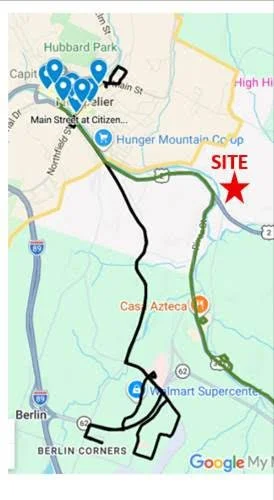
What guarantee is there that bus and shuttle routes will be established in time to serve this development?
Reliable service to Country Club does not currently exist. Green Mountain Transit (GMT)’s current service area is shown in the picture. GMT is transitioning to Tri-Valley Transit (TVT) in three months. Soon after that, and with the City’s leadership, we hope to speak with VTrans and Tri-Valley to divert the Montpelier-Barre route through Country Club after people start living there.
Rural Community Transportation (RCT) has Route 2 commuter route that could also serve Country Club.
GMT also has a MyRide on-demand service, but Country Club is not yet in its service area. From what we understand, regional and state authorities are open to expanding service for real demand.
What is the back-up plan?
If the Gopher plan does not work, and/or if there is not Tri-Valley Transit option,w e can always negotiate with commercial microtransit providers, or hire a driver service. This service would function much like Westview Meadows’ driver service.
In short, we foresee no more risk for this new, peripheral neighborhood than any other peripheral neighborhood in Montpelier. The difference is that we aim to solve the very real budget problem of owning a car for many Montpelier families.
Please note that until the village surpasses 60% occupancy, there is a 1:1 car ratio (or better) in those lots.